@w3asa
Active 4 months agoForum Replies Created
-
AuthorPosts
-
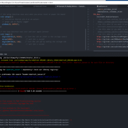
screen shot
Attachments:
I ran the “pio lib install” command and got the following:
Try to find answer in FAQ Troubleshooting section
https://docs.platformio.org/page/faq.html
* Report this problem to the developers
https://github.com/platformio/platformio-core/issuesCompile fails: “looking for Adafruit_sensor.h” and a couple of days ago compile was failing looking for “SODAQ…h” file.
I attached a screen shot of where I am stuck. Suggestions?
I figured out how to get terminal which is the sketch output window. Took a while to realize that the .ini file overides the terminal settings and was at the wrong baud rate to test output from my set RTC sketch.
I copied a SODAQ…h file to “lib” when the compiler was looking for that.
Next step is
pio lib uninstall xxxbut not sure what xxx is. Is it the “lib” folder in my current project?If so, should I just delete it and rerun pio lib update ?
Thanks
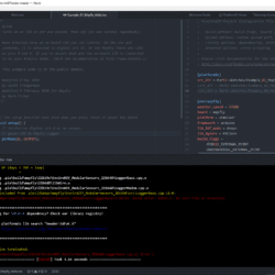
I have platformIO working with atom and get a compile error with the blink example. I checked https://github.com/EnviroDIY/ModularSensors/issues/247 opened a terminal but get a bash script error with “pio lib update”
How to I get to the terminal in atom?
attached a screen shot
Attachments:
Hi Beth-
I downloaded your tutorial that you started a 1 1/2 years ago. Is there any chance you finished it? It looks like just what I need as and Arduino IDE user trying to transition to PlatformIO. I have gotten a lot of information from Sara’s threads on this forum but looks like your tutorial would be very helpful for me.
Thanks
Jim
Hi Shannon-
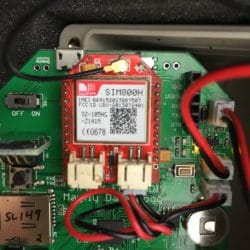
I think I will go with the 2G network for my project. I am not having much luck finding a source for the SIM800H. Adafruit has them but on a different board. I ran all the numbers on the attached photo thru Dr Google without much luck.
Can you provide me with appropriate links to purchase this and the other bits and pieces I would need to get my EC stations on the air. Also looking for the weather proof box with the clear lid for another project.
Thanks
Attachments:
Hi Evan-
I can’t provide any info on ThingSpeak and only have a limited knowledge based on some Dr Google research last night. I currently have six of my Low cost EC stations deployed in Great Marsh (N. Chester County) plus two of the Mayfly decagon stations (BCMC3S and..4S). The six EC stations are currently logging data to the µSD cards and have to be manually uploaded to MonMW which is rapidly losing its appeal! I have been thinking of using the LoRa 900 MHz radios. Without reinventing the wheel the LoRaWAN may be the way to go but that is currently above my pay grade!
My other option is to simply fit my 6 sensor stations with 4G radios. I am hoping Sara and Shannon can help me with that. I checked the Hologram pricing structure and its not at all clear what the base cost is. GMI is supporting the two Decagon stations and the cost is $8/month plus $.60 per month for the second device so I am assuming that my additional cost would only be $3.60 per month. Can someone confirm that?
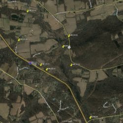
I have attached a GE image of the GMI array of sensors on most of the UNTs to the Great Marsh wetland.
Attachments:
A bigger issues is MonMW was off the air when I checked last night. There were no Sparkline plots and TSA was dead.
Does anybody know whats going on?
For what its worth I uploaded data to GMI_EC#6 last night and no missing data. However I had uploaded data earlier but had the wrong sensor order. I deleted these sesnors add re added them in the correct order. The sampling feature UUID did not change but the Result UUIDs did.
Here is what I uploaded:
—————————————-
Sampling Feature UUID: 43475bb1-37d3-4008-a98b-ff237110b7c2,
Date and Time in UTC-5,
Result UUID:,2cc3cf35-a2f3-40a1-b015-73a7925fb7d2,d6dfe83e-2c40-4a9d-81ea-c5e5391393e6,d478fc37-5cf0-4c51-bdd7-df728f2d6ebe,6bd9192f-c811-4799-a797-1d45689ca225,
2019-08-18 23:05:17,22.5,3.88,19.54,276
2019-08-18 23:10:17,21,3.88,19.54,275.5
2019-08-18 23:15:17,20.3,3.88,19.44,275.7
2019-08-18 23:20:17,20,3.88,19.44,275.3
2019-08-18 23:25:17,19.8,3.88,19.35,275.1
2019-08-18 23:30:17,19.8,3.88,19.26,275
2019-08-18 23:35:17,19.5,3.88,19.17,275.3
—————————————————–
Here is what the data I downloaded:
———————————————–
# Source Information
# ——————
# Organization: Great Marsh Institute
# SourceLink: /sites/GMI_EC%236/
# ContactName: Jim Moore
# Email: jom@marshlands.org
#
DateTime,TimeOffset,DateTimeUTC,EnviroDIY_Mayfly_Temp,EnviroDIY_Mayfly_Batt,SensorexTemp,SensorexCond
2019-08-18 23:05:17,-5:00,2019-08-19 04:05:17,22.5,3.88,19.54,276.0
2019-08-18 23:10:17,-5:00,2019-08-19 04:10:17,21.0,3.88,19.54,275.5
2019-08-18 23:15:17,-5:00,2019-08-19 04:15:17,20.3,3.88,19.44,275.7
2019-08-18 23:20:17,-5:00,2019-08-19 04:20:17,20.0,3.88,19.44,275.3
2019-08-18 23:25:17,-5:00,2019-08-19 04:25:17,19.8,3.88,19.35,275.1
2019-08-18 23:30:17,-5:00,2019-08-19 04:30:17,19.8,3.88,19.26,275.0
2019-08-18 23:35:17,-5:00,2019-08-19 04:35:17,19.5,3.88,19.17,275.3
————————————-
Note: No missing Mayfly_temp data -
AuthorPosts

 Welcome to EnviroDIY, a community for do-it-yourself environmental science and monitoring. EnviroDIY is part of


